webshop.nl
Categorieën
  Sluiten

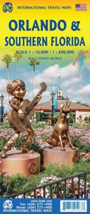
Wegenkaart - landkaart Orlando / Florida Zuid | ITMB

13,50

Webshops met dit product

Webshop
Bezorging
Prijs

Anderen bekeken ook

Wegenkaart - landkaart Miami and south Florida - Zuid Florida | ITMB
Gedetailleerde stadsplattegrond van Miami en het zuidelijke deel van Florida. Engelse taal, met register. This is a new title for ITMB. One side contains a detailed map of most of Miami and southern Miami Beach, showing the downtown, the expressways, and the cruise ship docks, as well as the major hotels along the beach. The other side covers all of Florida south of Cape Coral/West Palm Beach in excellent detail, including the famous Florida Keys. This is third most-visited touristic destination in the world, after Orlando and Las Vegas, and finally completes our detailed mapping for this densely populated US state. Printed on ITM plastic paper, double-sided Legend Includes: Roads by classification, boundaries, lighthouses, airports, points of interests, campgrounds, fishing sites, archeological sites, museums, parks, colleges and universities, and other information.
13,95
Wegenkaart - landkaart - Stadsplattegrond Orlando en Central Florida | ITMB
The title of most popular vacation spot on earth is claimed by two cities – Orlando and Las Vegas – both in the States. Sorry London and Paris, but apparently you’re down the list a ways. We don’t want to play favourites, so we’re publishing both cities, with Orlando coming out first. When one thinks of Central Florida, most people probably think of Disneyworld or other theme parks, and orange groves. There are a LOT of things to see and do in this part of Florida, which is why it is so popular with visitors. Surprisingly, good maps of the region are few, as we discovered during the IMTa map conference there a couple of years ago. Frustrated by inaccurate freebie maps and discouraged by the simplistic maps available from commercial firms, we’ve tried to create a ‘break-through’ map, combining the various attractions immediately surrounding Orlando itself, such as a detailed map of the Disneyland complex, the Universal Studios’ amazing theme area, and the hotel strip along Interstate 4,…
13,95
Wegenkaart - landkaart Florida Keys | ITMB
This fourth edition has a new cover photo, and a new locality map on the back cover that REALLY emphasizes just how close Havana and Key West are to each other! We have visited the area twice in the past couple of years and feel that the information is both accurate and comprehensive. The map also includes an inset of Key West showing every single street in the town. Finally, Johnny makes his introduction to the world of mapping by gracing the cover in what one hopes is a typical 'kid' pose (i.e. un-posed).   Legend Includes: Road by classification, Motorways, Main Roads, Rail Ways, Parks, Border, Lakes, Hotels, Motels, Viewpoints, Point of Interests and much more...
13,95
Wegenkaart - landkaart Accra & Ghana zuid | ITMB
Ghana was the first African colony to become an independent nation, in 1957. It may not be the largest, most populous, or richest country on the continent, but it is one of the best-managed and prosperous democracies. One seldom hears about Ghana on the news as a result, because there is seldom bad news to report! Accra is one of the oldest cities in sub-Saharan Africa, and the coast of Ghana is littered by historical remnants of trading forts built by the Portuguese, the Dutch, and the British during the age of expansion. Accra itself is an interesting city and our motivation in publishing a map of it is simply the reality that no map existed prior to this effort. The regional map shows Ghana's coastline to advantage and the interior of the country as far north as Kumasi.   Legend Includes: Roads by classification, Airports, Aerodromes and small aircrafts, Ferries, Bus terminals, Railway stations, Gas stations, Border crossing and custom posts, Hospitals, Museums, Tourist information …
13,95
Wegenkaart - landkaart USA Florida & Deep South | ITMB
Florida has been unavailable for far too long! We wanted to improve the area of coverage while converting the artwork to a GIS-based digital data base, so the area of coverage now includes Georgia, Alabama, part of Mississippi, and most of the Carolinas. This would be an excellent map to use on the way south (or north) along I-95 or I-85 through Atlanta or Augusta and south to the Gulf Coast. The Panhandle of Florida is on the same side of the sheet, with the second side being devoted to Florida south to the Keys. There isn't enough space to show many insets; just the Orlando area and a Florida map showing population by counties. Another innovation we have introduced is to print the map on waterproof paper, for durability as well as for use as an umbrella during sudden downpours! Legend Includes: Road by classification, motorway, two land road, railway with station, waterway and much more...   Deep South, schaal 1: 1000000 Florida schaal 1: 720000
13,95
Wegenkaart - landkaart - Stadsplattegrond China South - Zuid | ITMB
Een degelijke wegenkaart met aanduidingen van o.a. nationale parken, vliegveld, benzinepomp, dirt-roads. Als overzichtskaart goed te gebruiken.   China is a very large country. While our map of the entire country is fine for general travel and sells well, China is too large to show areas in detail. This map concentrates on the part of China from Shanghai south and all the way west to Lhasa and includes Taiwan and Hainan Island. We are not trying to make any sort of political comment here, but geographically, both Tibet and Taiwan fall within the area of coverage and are both included for this reason alone. The map also includes insets of Hong Kong, Guangzhou and Shanghai   Legend Includes: Roads by classification, Points of Interest, National Parks, Airports, Golf Courses, Beaches, Campsites, Waterfalls, Viewpoints, Churches, Surfing/Scuba Diving Spots, Fishing Spots, Hospitals, harbours/Ports, Lighthouses, Museums, Monuments, Caves, Mosques, Mountain Peaks, Botanic Gardens, Wildlife S…
13,95
Wegenkaart - landkaart Zuid Afrika - South Africa | ITMB
Uitstekende wegenkaart van Zuid Afrika met zowel de toeristische informatie als Nationale Parken en bezienswaardigheden, maar ook de topografische details en afstanden. Gedrukt op 'waterproof' papier. Double-sided map of South Africa printed on waterproof and tear-resistant synthetic paper, with plans of Cape Town, Johannesburg and Pretoria. The map divides the country east/west with a small overlap between the two sides. Elevation tinting in feet shows the general relief. Mountain passes are marked, but there are no spot heights. Road network includes selected local tracks, gives driving distances on major and secondary roads and indicates border crossings. Railways, major ferry connections and local airports are also shown. National parks and protected areas are marked and symbols highlight various places of interest, campsites or huts, rest houses and other tourist accommodation, beaches and diving sites, etc. Presentation of Lesotho and Swaziland is the same as for South Africa. La…
13,95
Wegenkaart - landkaart Southern Quebec - Zuid Quebec | ITMB
Een degelijke kaart met aanduidingen van o.a. nationale parken, vliegveld, benzinepomp, dirt-roads en kleine plattegrond van hoofdstad. Als overzichtskaart goed te gebruiken. La Belle Province has a lot in common with Ontario. It is a huge political entity, with most of the land mass unusable due to permafrost. Almost all the roads and settlements are in the southern half of the province, so we expanded the scale of our artwork and created a map that will be of greater practical use for visitors than one of the entire province. Even so, the distances are formidable (say it in French; it sounds much more dramatic!) Side one concentrates on the region north of Montreal, and includes the Canadian Shield region of Abitibi. The second side follows the St. Lawrence River eastward to Quebec City, where one can continue eastward on the north shore for hundreds of kilometers or cross over an enormous bridge to the south shore and do essentially the same; ending up in the picturesque Gaspe Penin…
13,95
Wegenkaart - landkaart South America - Zuid Amerika | ITMB
Een degelijke kaart met aanduidingen van o.a. nationale parken, vliegveld, benzinepomp, dirt-roads en kleine plattegrond van hoofdstad. Als overzichtskaart goed te gebruiken. ITMB is very pleased to release a new, digitally-prepared, double-sided map of South America. It covers the entire continent in great detail and has been able to capture the information on the 'old' map, while using the expanded scale of the new map to add and enhance countless details that were crammed on to the earlier editions or for which there was inadequate room to include. This is the most detailed continental map of this part of the world ever published. Legend Includes: Railways, ferry routes, roads by classification, international and domestic airports, rivers, lakes, points of interest, archaeological sites, beaches, lighthouses, mines, glaciers, volcanoes, national parks and other information.  
13,95
Wegenkaart - landkaart - Stadsplattegrond Thailand zuid South - Bangkok | ITMB
Duidelijke wegenkaart met op de ene zijde de kaart van Bangkok op een goede schaal met veel toeristische informatie. De andere kant heeft het hele zuiden van Thailand .   Bangkok is a very interesting city, with many temples, pagodas, and historic buildings. It is also an airline hub and, as a result of not being a member of IATA, is a bargain-lover city for lower-cost airfares. This updated edition includes the new airport, recently-completed transit lines, and additional information for embassies. In this edition, we have combined our city map with a travel map for the southern half of the country, which means the peninsula connecting to Malaysia and including the most-visited parts of Thailand, the beach resorts located in the vicinity of Phuket. We have also upgraded it to plastic paper, both for the tropical humidity and for durability.    Map size: 27*39"   Legend Includes: Roads by classification, motorway, expressway, provincial highway, river, national park, waterfall, tourist…
13,95

Klanten-reviews van Wegenkaart - landkaart Orlando / Florida Zuid | ITMB

Er zijn nog geen beoordelingen voor dit productBen jij de eerste die een review plaatst?

Meer over Wegenkaart - landkaart Orlando / Florida Zuid | ITMB

Webshop.nl maakt gebruik van cookies. Ga je verder op onze website, ga dan akkoord met het plaatsen van cookies en de verwerking van deze data door ons en vermelde partners.